The Copper Canyon in northern Mexico are a beautiful area often compared to the Grand Canyon.
There are a few ways to explore the Copper Canyon: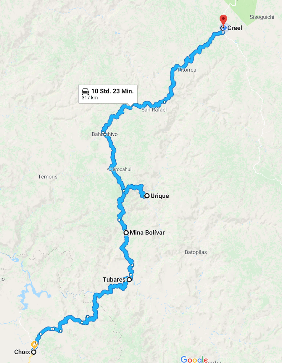
- Take the train, El Chepe. This is the most popular option by far, with a daily train traveling between Los Mochis and Chihuahua and making many stops between. The trip is long and you rely on tours from the towns on the route if you want to explore more – and not a dog friendly adventure.
- Drive around to Creel, a nearly 1000km detour, and start touring from there. The landscape and towns along the detour are not spectacular, so this option was less appealing.
- Go off the beaten track and drive straight through from Choix to Creel.
Our choice was obvious.
Between Choix and Creel we had a lot of questions about safety and quality of roads. There isn’t a lot of information online about what route to take and how to find the way. In addition, there is some cartel activity in the area, so we didn’t want to take the wrong road and find ourselves in the midst of a plantation. After a bit of searching and some luck, we got first hand information about the route from previous travelers and their blogs. Their information and success gave us the confidence we needed to power ahead.
Our biggest question was: Is the route safe?
The situation in the region can change at any time, so checking with local tourist offices is a must. We went to the tourist office in Choix, and they were super nice and helpful, confirming the road is safe to travel and they printed out a google satellite map with points along the route for us. The road from Choix was traveled by dump trucks traveling to a gold mine at Piedras Verdes, so we weren’t on completely isolated roads. The roads aren’t in good condition, but we felt safer passing a few other drivers on the way. The 170km journey from Choix to Urique is slow going – mostly driving in low gear under 20km/hr – so we left early in the morning to make sure we arrived in Urique before dark. We had a small break during the drive, when we got caught behind a broken down semi truck. We used the hour to make coffee, have a small snack and try to chat with one of the truckers with our very rudimentary Spanish. Dispite that small delay, we had no trouble following the road and the views on the way were amazing.
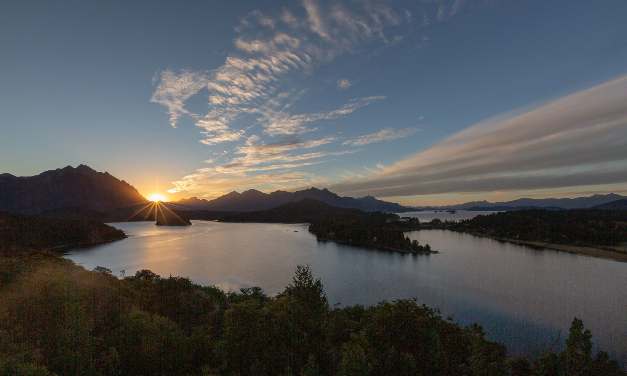
After 9 hours, we finally arrived in Urique! We made our way to Entre Amigos, the only camping area in town. It was an expensive spot to camp compared to where we had been so far, but for the safety and comfort out in the middle of nowhere, it was well worth it. We had hoped to do some hiking in the canyons with a guide, but nobody was willing to take tourists far off the roads and for a steep price. Instead, we stuck to some dirt roads heading to another village, Guadalupe. Even though we weren’t on proper trails, it was a lovely walk with more amazing views. After two nights in Urique, we decided to head up the canyon a ways and camp out at a lookout point 1000m above Urique. We were rewarded with a beautiful sunrise the next morning (as well as some cold weather!)
The next day we continued on towards Divisadero, home of the Copper Canyon “Adventure Park”. A lot of tourists taking the train come here to hop on the gondola to a lookout point – which was not too far from our camping spot that morning. We skipped the crowded gondola and instead headed on towards Creel. We didn’t expect too much out of Creel, even though it is a major stopping point for those traveling by train. A lot of tours take off from the station there, but the town itself offered little more than a few places to eat, some hotels, and an ATM. We opted to camp at a nearby lake and hike around. The trails took us to a local Tarahumara village and some rock formations. The Tarahumara are an indigenous culture that live in the region and are especially known for their long distance running skills.
We spent another day around Creel, visiting the museum and walking around the very small village. In the evening, we got to experience the town’s celebration for Day of our Lady of Guadalupe. A parade of semi trucks drove down the main street into the town square, decorated in balloons, lights, and images of Our Lady of Guadalupe, and HONKED their horns and REVED their engines. We didn’t know there was going to be this parade, but it was impossible to miss! After a loud but amusing evening, we headed to our absolute highlight location so far in Mexico.
Basaseachi Falls is about 2 hours from Creel and absolutely beautiful! The landscape blew us away. From the parking lot for the National Park, you get a panoramic view of the Falls and surroundings. From there, we hiked to the bottom of the falls, about 400 meters down, and had lunch next to a small pool of water at the falls base. We then hiked the steep trail back up – not easy when you have only been at 2000m elevation for a few days. We were able to camp in the parking lot at top for free, and enjoyed a peaceful night with the Falls all to ourselves. This is an absolutely magical location and a must see if you visit the Copper Canyon region!
Hallo Ihr Beiden,
durch Zufall sind wir auf Euren Beitrag zum Copper Canyon gestoßen. Wir sind zur Zeit in La Paz (Baja California) und werden in zwei Tagen nach Los Mochis übersetzen um ebenfalls die Strecke von Choix nach Creel zu fahren.
Könntet Ihr uns noch ein paar nähere Infos zum Zustand der Strecke geben? Ist sie steinig/ausgewaschen/Waschbrett oder relativ gut unterhalten? Wie viel Kilometer sind eher schlecht und wie viele eher gut?
Über die Infos würden wir uns freuen, damit wir den Zeitbedarf etwas besser einschätzen können.
Von Creel wollen wir übrigens nach Texas und dann weiter nach Florida. Vielleicht laufen (fahren) wir uns ja irgendwo über den Weg.
Vielen Dank für jede Info und viele liebe Grüße aus La Paz
Gaby und Dirk
Hoi zäme!
Der Weg von Choix nach Urique ist eigentlich ein Feldweg der alles bietet: steinig, ein paar ausgewaschene Stellen, ein paar Waschbrettpassagen und, wenn es regnet, viel Schlamm, ansonsten Staub (vor allem um die Minen rum). Fuer die rund 170km von Choix nach Urique haben wir 9 Stunden gebraucht, inkl. 30min Wartezeit hinter einem kaputten Minentruck, oftmals in der Untersetzung hoch und runter. Wenn ich mich richtig erinnere, waren es rund 3 Stunden, um vom Mirador nach Creel zu kommen.
Ab Cerocahui ist die Strasse geteert, da gehts dann schneller vorwärts.
Ich hoffe das Hilft 🙂
Lg, Ben & Rachel, momentan in Playa del Carmen, Mexiko