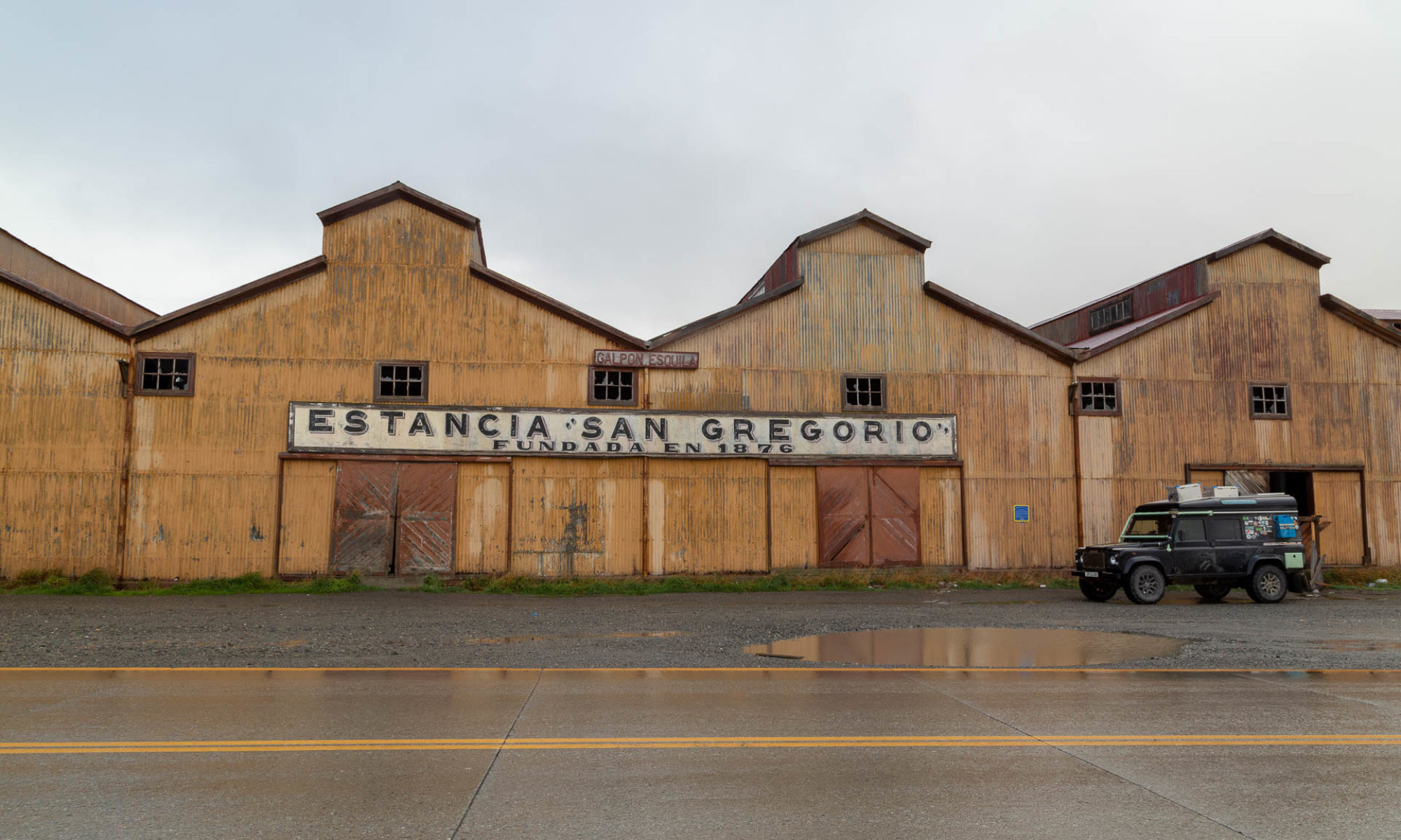
Baños
In a valley below an active volcano is the resort town of Baños. It is a town well past its prime, with a number of abandoned buildings interspersed between the hotels and souvenir shops.
The volcano that provides hot thermal waters erupted back in 1999 and the post evacuation effects are still visible. The town is still alive and has a unique charm to it. Rachel took a special liking to the town because the residents seemed to care for all the street dogs and kept them well fed. During a visit to the local coffee shop, an older dog wandered up to the door looking tired. The shop owner came out with water and food and sat with the dog for 5 minutes to make sure he got enough to eat and drink. The town also has a small statue and mural dedicated to dogs. It is a nice change from the usual street dog problems of Latin America.
It turns out the volcanically warmed hot springs that give this town its name are the least appealing part of the town. Our quick trip into the local watering hole lasted all of 10 minutes, when we were grossed out by the shoulder to shoulder sardine like bathing. Luckily there is a lot more to see and do! We hiked to La Casa del Arbol (where you can also drive to, which we would recommend over the steep climb up) and enjoyed the view and giant swings. It’s a bit touristy but beautiful, and only $1 entrance.


The area has a lot of beautiful waterfalls, many free along the road. The especially impressive and famous one is known as El Pailón del Diablo. A small entrance fee and a short walk downhill led to the powerful falls.


We hiked partway up the Volcan Tungurahua above Baños until the refugio. It is a short and steep trail (1000m gain over 3.8km) and great training for our next big hike. We rewarded ourselves with a couple nights at a beautiful campsite along the river.


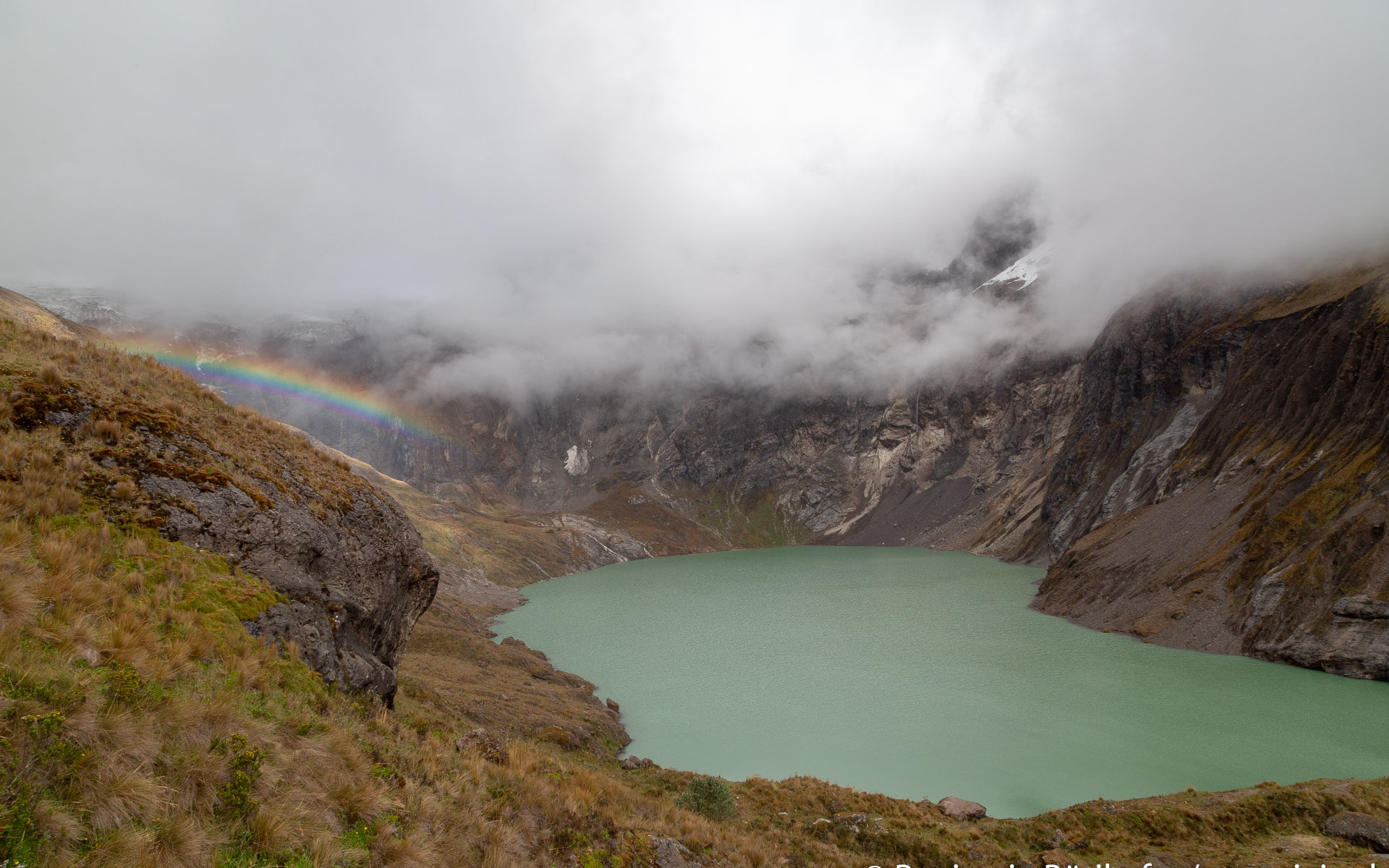
Laguna Amarilla / El Altar
Below the 9 peaks that form the massif El Altar is a beautiful glacier lake, Laguna Amarilla. El Altar is believed to have once been the worlds tallest peak before an explosion in the 1400’s which formed the crater the lake sits in. To reach the Laguna, you need to hike a long and muddy trail (Round Trip 27km/17m and 1750m/5700ft elevation gain). In bad conditions, the mud on the trail can get knee deep and it is really slow moving. Most people make this a 3 day trek, spending two nights at a Refugio located a below the lake. We were bringing Mitzi and didn’t feel like packing for 3 days, so we turned the hike into a 2 day trek by combining Days 1 and 2.
We couldn’t find a lot of information about the trail itself before going, so here is some data for anyone thinking to go:
- Parking at Hacienda Releche costs $5. You can also camp there for $20, which is a bit steep in our opinion.
- Hacienda/Car Park to Refugio: 10.5km, 1050m elevation gain. We took 4.5 hours, but we had the benefit of fairly dry conditions and the detriment of a wiener dog that kept jumping into deep mud instead of walking around it and standing there until someone rescued her. The first 2km of the trail is steep uphill, and the last 4km has a lot of up and down.
- Refugio to Laguna and Return: 6.7km with 450m gain. First stretch you have to find your way through a marshy field. Most people come up here with rubber boots and they would have been really helpful here. Then there is a steep climb and you gain most of the elevation over the last km.
- Refugio back to the Hacienda: 10.5km with 250m elevation gain. It rained overnight and on and off on our way down, so the trail was pretty muddy and gross. Rachel had to carry Mitzi which slowed her down, plus navigating the trail became a lot trickier! It took us 4 hours to go down, which shows just how much the trail conditions affect you here.
- The Refugio Cost $15pp per night, including use of the kitchen. We were off season so we got a whole room to ourselves. The beds aren’t the most comfortable, but we were glad to be inside when the rain picked up at night! If you bring a tent you can camp for free past the Refugio. There was a nice tucked in spot halfway up to the lake.
- If you have any questions about availability you can contact the Hacienda Releche via Whatsapp on the following number: +593 98 464 9634
The Laguna was beautiful and worth the effort to get up there. The trail conditions were rough and not for non-hikers. We were fine in good hiking boots, but in the rainy season rubber boots would go a long way! The muddy mess on the way down was probably the worst trail conditions either of us has experienced. It’s a lot of work but that also means you won’t find a ton of people up there. The experience of sitting above such a gorgeous lake without another person in sight was magical.


Chimborazo
Our final destination and hike before hitting the beach was at Chimborazo, the tallest volcano in Ecuador. We spent a night near the mountain with howling winds that kept us awake most of the night. There are a few short hikes one can do around the volcano, but because of our lack of sleep we just did the short one to Laguna Candor Cocha, at 5100m. Climbing up from Riobamba the scenery changes dramatically – from a lush green valley at about 2800m until a barren dusty and dry volcanic landscape opens up. There are still some flowers and weeds growing up there, but most exciting are the number of Vicuñas living up there. This shows that even though the landscapes looks very hostile to life, there is life thriving up here. This area is also home of the Polylepis trees, a small sturdy tree that (very slowly) grow at elevations between 4000m – 4850m in the Andes.


After all this hiking and high elevations, we figured it is time to check out the coast of Ecuador! We made a quick stop at a cheese factory in Salinas (best cheese in South America so far) then hit the road to the Pacific!
Die Vulkanlandschaften erinnern mich zum Teil an Santorini, nur der Höhenunterschied ist sichtbar. Fantastisch die Panoramaansichten, man ist mittendrin und erlebt es mit Euch, danke! 5100m, nicht schlecht. Super, dass Ihr die jungen Jahre so nützen könnt. Macheds witer guet, liebi Grüess, Mami